Slope Stabilization and Protection Project for the Southern Access to Sardoal
Municipality of Sardoal
Introduction
This article presents the project plan focused on slope stabilization and drainage systems on the natural slope of the Southern Access road to Sardoal. The technical intervention integrates the specialties of geology, earthworks, and drainage to ensure the compliance and safety of the local road infrastructure.
Project Context and Needs
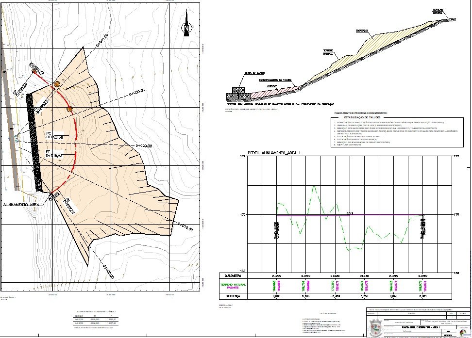
The intervention area is characterized by a steep slope, resulting from excavation for the construction of the existing road. An excavation slope (designated as the Right Slope) was identified, with an approximate length of 144 meters and a maximum height of 16 meters, where localized instabilities and rockfalls were occurring.
The degradation of the structure is due to physical and chemical processes that weaken the mechanical properties of the geological materials, composed mainly of Mouriscas Orthogneisses and Migmatites. Factors such as rainwater infiltration, wind erosion, and the presence of medium and large vegetation were identified as accelerating agents of instability, increasing the risk of landslides and falling debris onto the road.
Summary of the Project Completed
The solution adopted was based on a set of preventive and corrective measures structured in the following phases:
- Earthworks and Resurfacing: Clearing and removal of unstable materials and loose blocks were carried out. The slope was resurfaced to smooth its gradient, using long-reach equipment to ensure operator safety.
- Stabilization and Safety: Global stability was verified through automatic calculations (Bishop’s method) and pseudostatic analyses for seismic scenarios. A high-strength protective net was installed to contain falling debris, and a gabion wall at the foot of the slope served to retain materials and dissipate energy.
- Drainage System: A longitudinal drainage network was designed, consisting of trapezoidal slope-top ditches lined with concrete, semicircular downpipes, and energy dissipators. The hydraulic design was calculated using the Rational Method for 20-year return periods, ensuring the correct direction of rainwater to the discharge point.
- Technical Monitoring: The project stipulated the mandatory continuous geological mapping and monitoring by geotechnical specialists during execution, ensuring verification of safety conditions and adaptation of solutions to the characteristics of the soil mass observed during construction.
Explore other infrastructure projects in our portfolio. If you would like additional technical information about our engineering solutions, please contact us directly using the form available on our website.
Discover how we can make your project a reality.
Get in touch with us and let’s create something extraordinary together.
ENVISQUANTIS, LDA
Links
Follow us on social media:
Copyright © 2025 Envisquantis, LDA