Biscainho Street Redevelopment Project – Coruche
Municipality of Coruche
Introduction
This article details the execution project for the requalification of Rua do Biscainho, located in the parish of Biscainho, municipality of Coruche. The intervention, promoted by the Coruche City Hall, is part of a strategic plan for the rehabilitation of road infrastructure southwest of the municipality’s headquarters. The study was based on georeferenced topographic surveys (scale 1/500) and military cartography, ensuring the technical rigor necessary for the modernization of this public space.
Context and Need
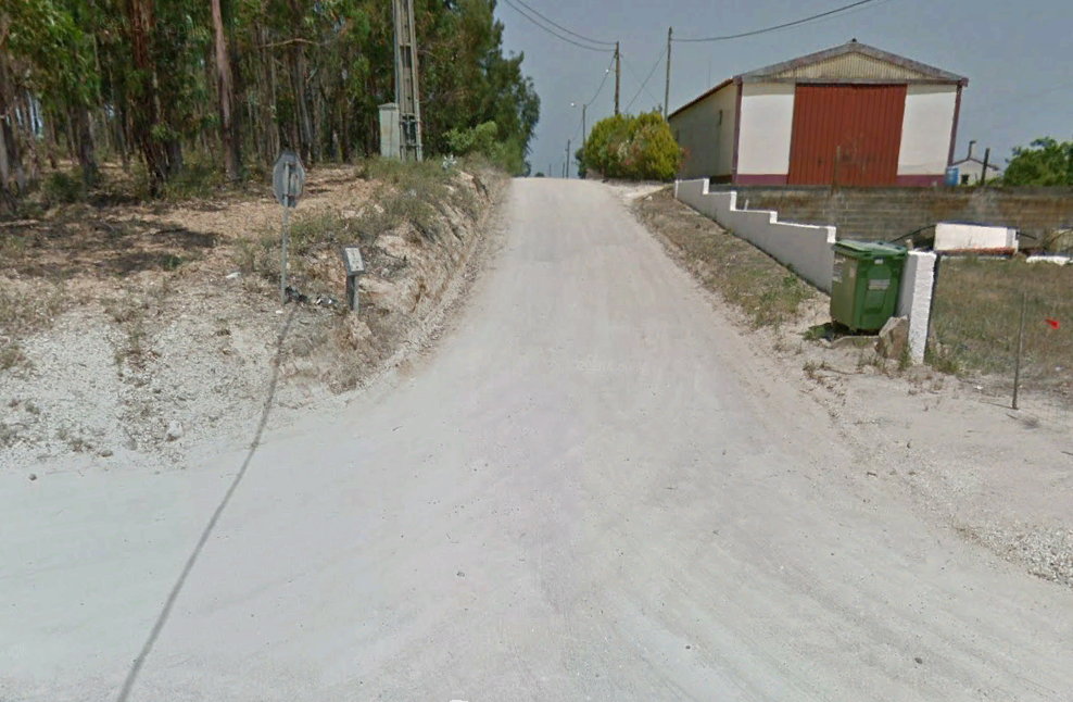
Currently, Rua do Biscainho is unpaved, serving as access to various properties and lots scattered throughout the area. The street has a consolidated layout, but is limited in several places by the presence of perimeter walls and buildings, which restricts the available width for the roadway and pedestrian walkway.
The need for this project is related to the urgent need to provide the street with safe and comfortable circulation conditions, establishing visual and functional continuity. The main focus is improving conditions for pedestrian users, especially in areas with higher building density, where the lack of paving and structured sidewalks compromises the mobility and safety of all users.
Summary of the Project Completed
The technical solution developed by Envisquantis focused on the complete rehabilitation of the road, respecting a base design speed of 50 km/h.
- Geometry and Layout: The road axis extends for approximately 1,039 meters, connecting EM 515 to the area surrounding the Equestrian Center. The layout adapts to the existing one to respect the threshold elevations, with the new grade situated between 15 cm and 20 cm above the current level. At specific points, the grade was raised by 1.3 meters to ensure adequate access to Monte de São Pancrácio.
- Cross-section and Mobility: Implementation of a traffic lane with one lane in each direction. Elevated sidewalks were designed with widths between 1.20 m and 1.50 m, guaranteeing a minimum of 0.90 m in areas with greater lateral restrictions caused by existing walls.
- Structural Pavement: The road received a new structure composed of a wearing course (4 cm), a tack course (6 cm), and a granular base of crushed aggregate (25 cm). On the sidewalks, concrete blocks (paving stones) were chosen over a sand and cement cushion.
- Stormwater Drainage: Detailed study of transverse and longitudinal drainage, including triangular ditches and sumps with metal grates integrated into the sidewalks. The system was designed for a 20-year return period, ensuring the longevity of the infrastructure against the effects of precipitation.
- Signage and Safety: Complete plan for horizontal and vertical code signage (0.70 m in diameter), installed at a height of 2.20 m to ensure safety in an urban environment without obstructing pedestrian circulation.
- Earthworks: Execution of cleaning, clearing, and stripping works (0.20 m), with excavation slopes at a 1:1 inclination and fill slopes at 1/1.5.
With a vast portfolio of infrastructure and urban planning projects, Envisquantis ensures compliance with all technical and regulatory standards. We invite you to explore our complete portfolio to understand the depth of our work.
Do you need specialized technical support for your project? Our team is available to collaborate on exceptional quality architectural and engineering solutions. Contact us.
Discover how we can make your project a reality.
Get in touch with us and let’s create something extraordinary together.

ENVISQUANTIS, LDA
Links
Follow us on social media:
Copyright © 2025 Envisquantis, LDA